Looks like an active day shaping up across portions of Nebraska, South Dakota, Iowa and Minnesota today! PDS Tornado Watch already up in northern Nebraska.
Programming note: I will not be able to do an update this Thursday, so an update will be posted on Friday instead.
1-3 Day
Monday
Central Plains, western Midwest — TORNADO RANGE: 5-12 — CONFIDENCE: Normal
Expected Tornado Hotspot: Eastern Nebraska, southeastern South Dakota, Iowa
Pros: Good/strong speed and directional shear, moderate to high instability, possible enhancement through boundary interaction
Cons: Storm initiation/coverage of discrete storm concerns, possible quick transition to a MCS, lackluster upper-level forcing
Tuesday
Northern Plains, northern Midwest, northwestern Mid-Atlantic — TORNADO RANGE: 2-6 — CONFIDENCE: Normal
Expected Tornado Hotspot: Northern Plains
Pros: Decent/good directional shear, moderate to high instability, good upper-level forcing in the northern High Plains
Cons: No appreciable upper-level forcing east of the Plains, SW/WSW flow in most of the Midwest, capping concerns
Wednesday
Plains, northwestern Midwest — TORNADO RANGE: 1-4 — CONFIDENCE: Normal
Expected Tornado Hotspot: None
Pros: Decent/good directional shear in the Midwest, decent/good upper-level forcing in the northern Plains, moderate to high instability
Cons: Backing wind in the upper-levels in the Plains
4-7 Day
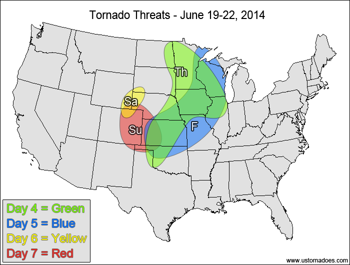
Thursday
Central and northeastern Plains, western Midwest — TORNADO RANGE: 1-4 — CONFIDENCE: Normal
Expected Tornado Hotspot: None
Pros: Decent/good speed and directional shear, moderate to high instability
Cons: Mid-level speed shear is somewhat weak in spots, no appreciable upper-level forcing
Friday
Central Plains, western Midwest — TORNADO RANGE: 0-3 — CONFIDENCE: Normal
Expected Tornado Hotspot: None
Pros: Decent/good directional shear, moderate to high instability
Cons: fairly weak speed shear in the mid to upper levels
Saturday
Central High Plains — TORNADO RANGE: 0-2 — CONFIDENCE: Normal
Expected Tornado Hotspot: None
Pros: Some upslope, low to moderate instability
Cons: Weak speed shear
Sunday
Central High Plains — TORNADO RANGE: 0-3 — CONFIDENCE: Normal
Expected Tornado Hotspot: None
Pros: Decent/good upslope flow, moderate instability
Cons: Somewhat weak speed shear in the mid to upper levels