A historic storm system swept through the central, southern and eastern U.S. from Friday through the weekend. Led by experts at federal government’s National Weather Service offices, the event was extremely well forecast and warned.
Responsible low pressure caused a dangerous dust storm that plagued a region from the Southern Plains to the Upper Midwest, a fire outbreak in Oklahoma and Texas, then a swarm of killer tornadoes further east.
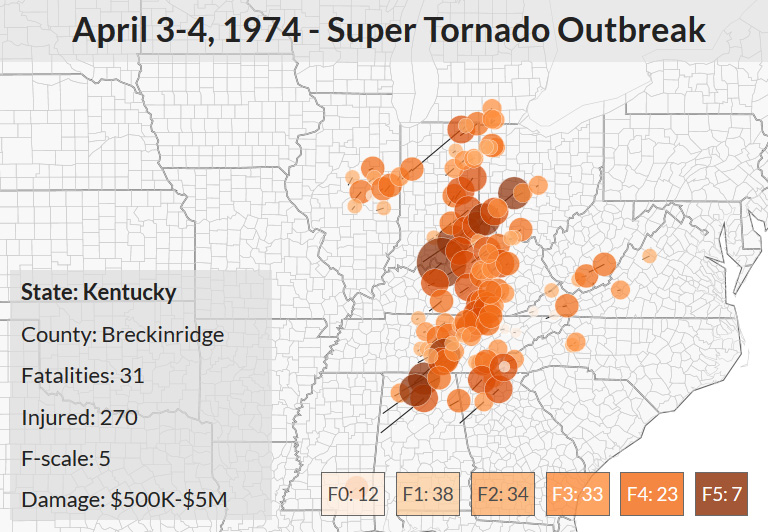
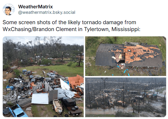
Among the slew of tornadoes, a high-end EF4 on a 0 to 5 scale, the strongest to hit the country since spring 2023.
While dozens have been confirmed killed by the storm system, it could have been much worse.
Rumors of storms, then storms
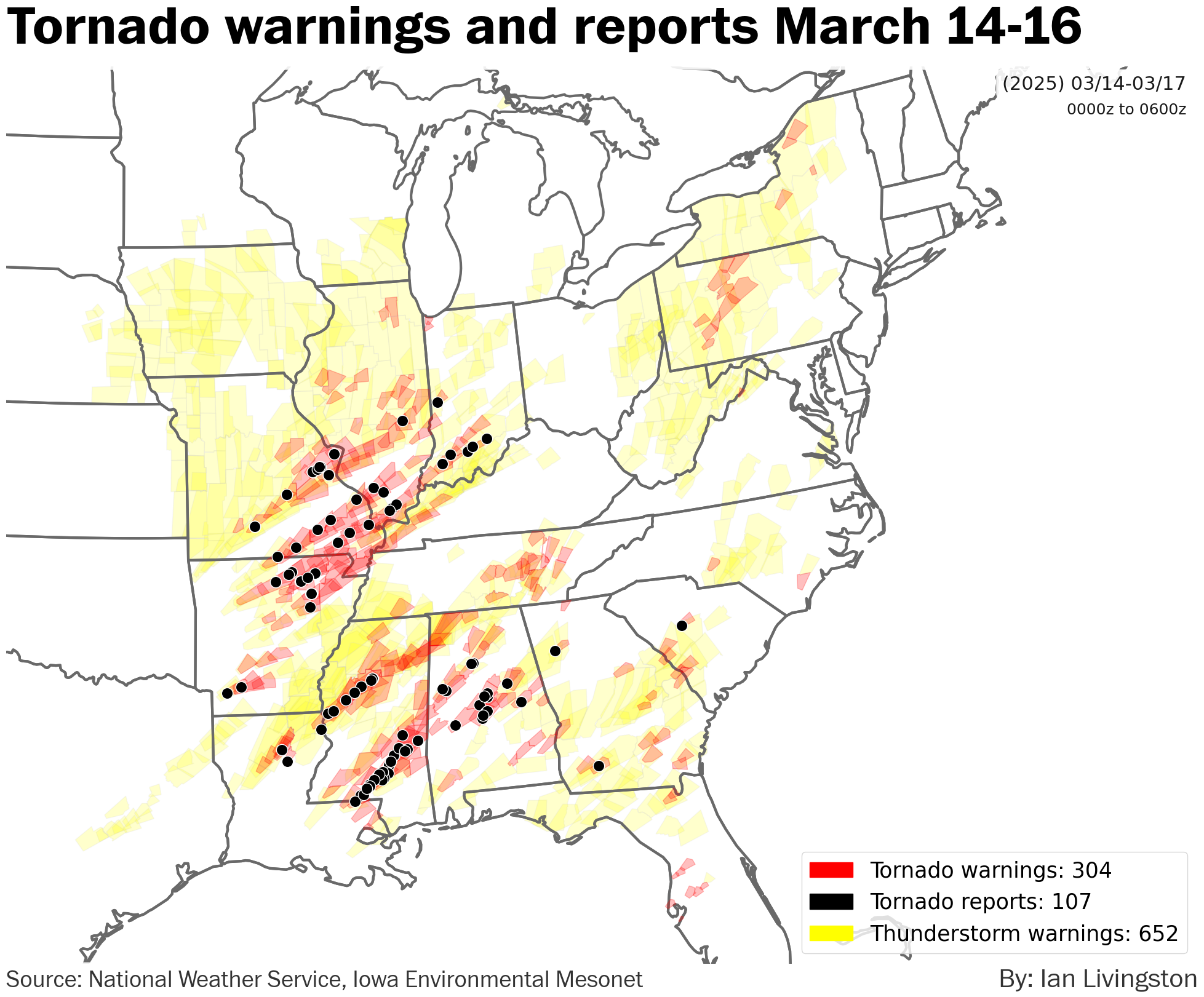
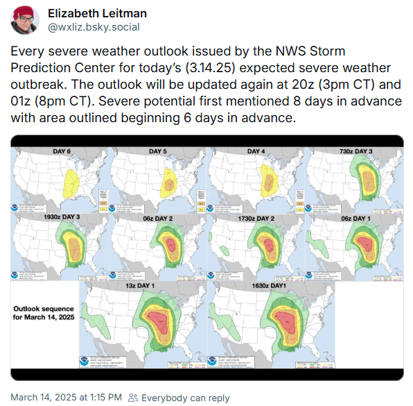
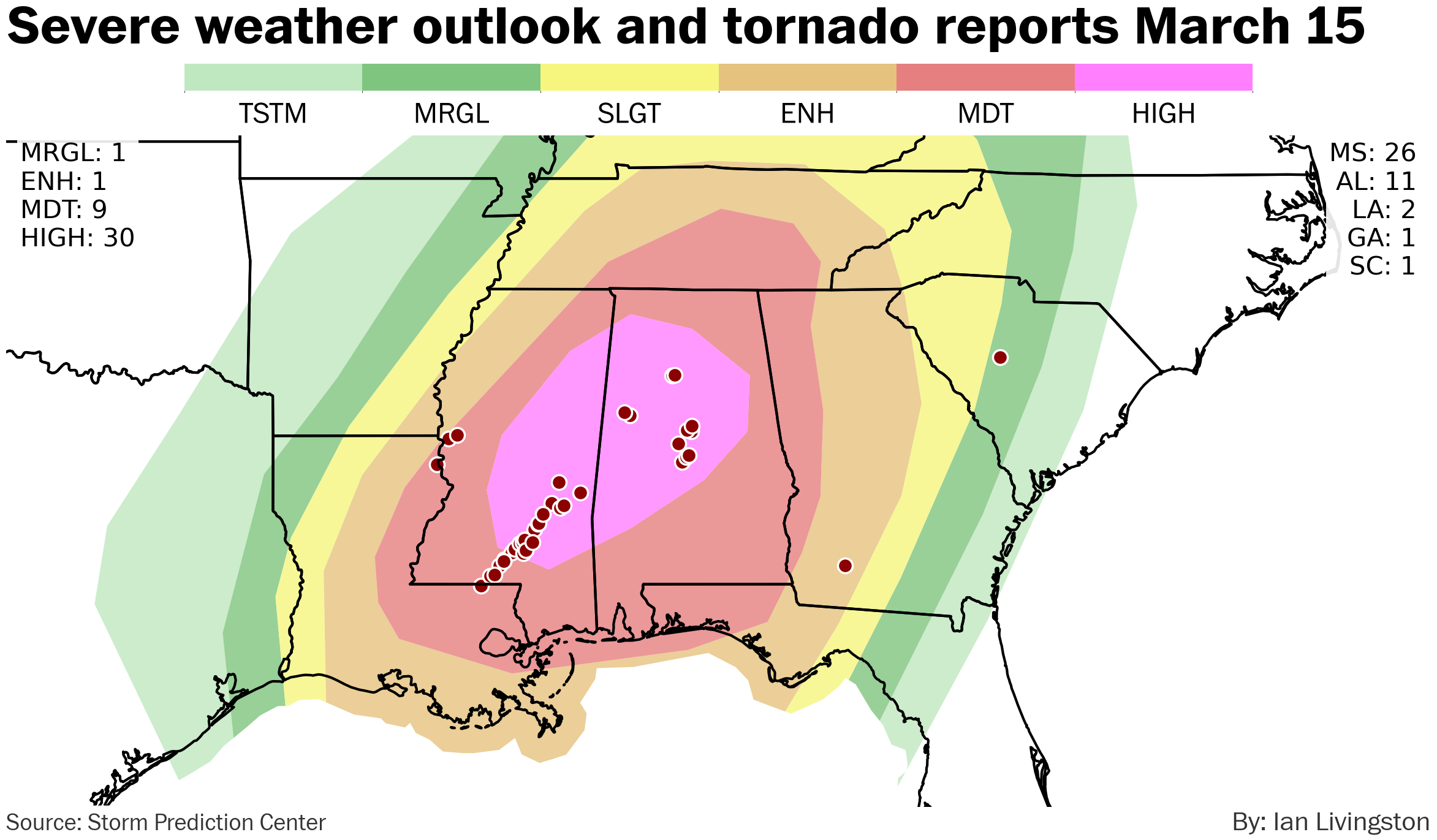
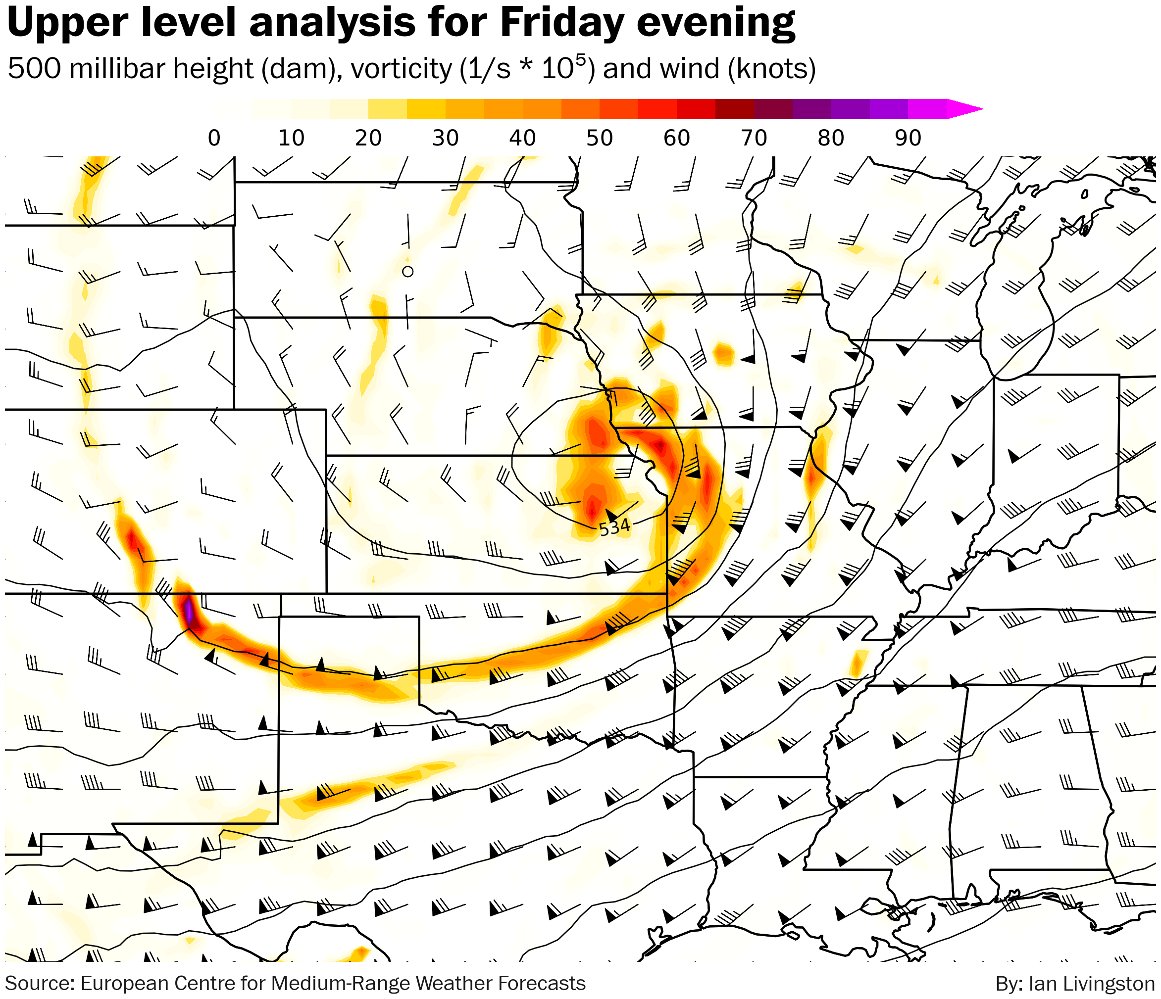
The first signs of trouble emerged more than a week in advance on weather modeling — run after run spit out an unusually strong Plains low. The Storm Prediction Center (SPC) outlooked the threat from six and seven days out. Their first outlines for severe storm risk ended up encompassing all but a handful of tornado reports on the key days.
On Friday all but two of the tornado reports were in the Level 4 and 3 risk areas. Saturday was the same story but for Level 5 and 4 — 75 percent of the day’s tornado reports were in the Level 5 risk area.
Success in determining severe weather locations well in advance is intertwined with the ability to accurately forecast the big picture. In this case, forecasts for the intensity of low pressure and its location were just about perfect from range.
With bean-shaped rotating supercell thunderstorms filling radar screens Friday night and again on Saturday, local Weather Service offices took over the lead, delivering life-saving warnings. Numerous other agencies — government and private — also came together to provide a blanket of short-term assistance to citizens directly impacted.
Importance of NWS cannot be overstated
It was exactly two weeks before the Friday tornado swarm that I wrote: “Coming out of a La Nina winter, odds are higher than normal that severe weather will be intense in the Southeast early in the spring season.”
You might say that several dozen still died so more work is needed. People involved in all aspects of the past week would agree.
Even with tons of lead time and perhaps a slight underperformance in coverage Saturday, it was very rough. We can largely thank overlapping risks more common of early-spring storm systems:
- Speedy thunderstorms and long-tracks. Rotating supercells moving at highway speeds can deliver many miles of destruction in a short time.
- Population focus. Peak tornado season backs northwest from the Gulf and South to the Canadian prairies — early season tends to favor zones with higher population density.
- Nighttime tornadoes. As forecast, Friday storms fired up and peaked after dark. Consider the above, but at night when people are often sleeping.
Some factors cannot be fully overcome.
Indeed, much of the issue today is at a communications level in the immediate leadup and during a severe weather event. Key is ensuring not only a higher percentage of people receive timely warnings but also making sure they know what to do and where to go at a moment’s notice.
NWS plays a critical role not only when sirens are blaring, but in education that occurs months and years prior to the storm hitting. One sure way to ensure people do not get proper details is to slash important governmental services.
Amid politicians fighting about whether or not they should pay scientists for their work, NWS employees dutifully watch, ready to push life-saving alerts to phones and weather radios at 2 a.m.
There were more than 300 tornado warnings, and 600 severe thunderstorm warnings, issued from Friday through Sunday.
Everything but locusts
The Plains is where weather goes to happen. This was nonetheless a memorable event there.
While tornadoes are the sexy news story, a dozen were killed by other severe weather in this episode. Damage was much more widespread from wind if also mostly less spectacularly devastating.
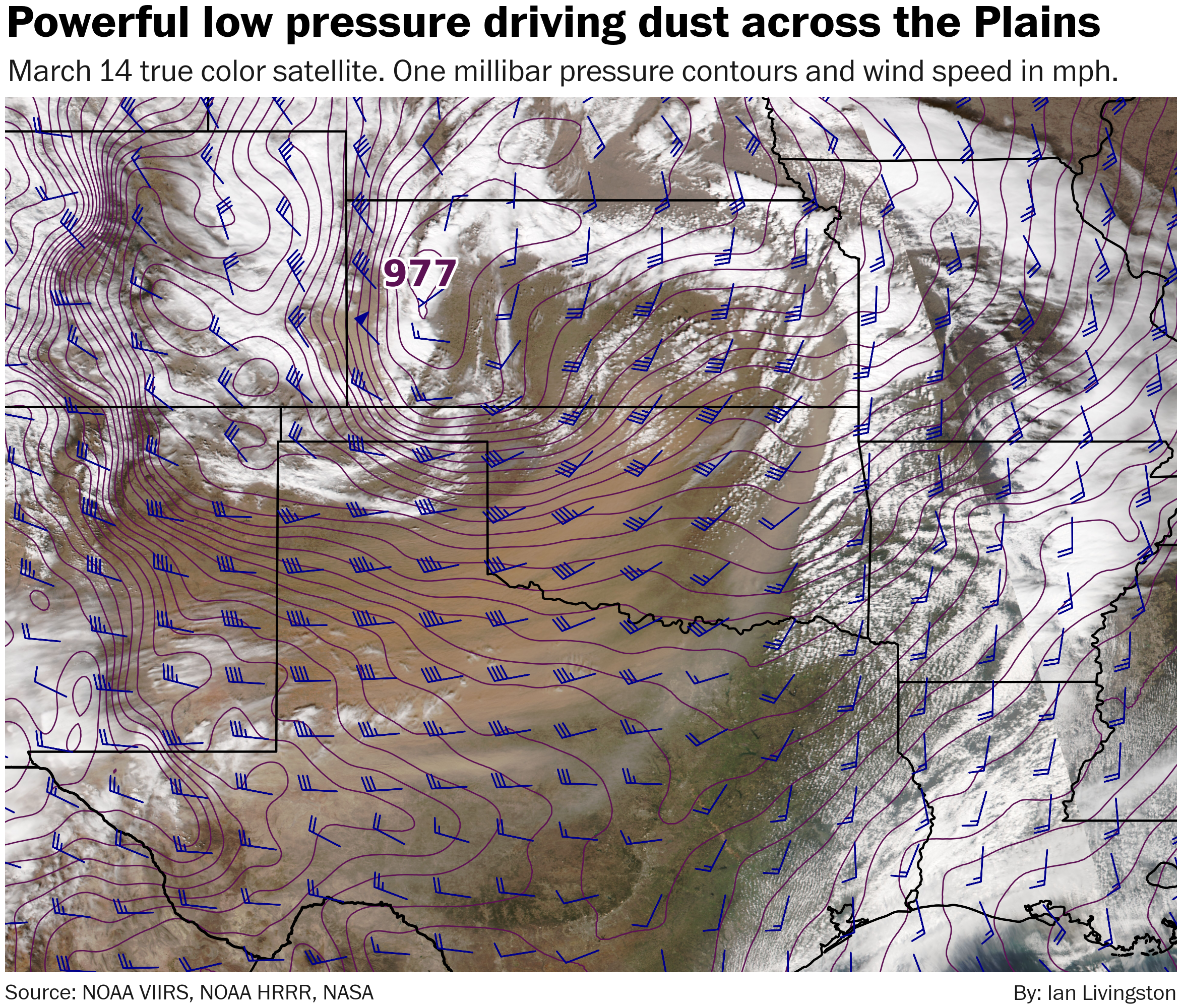
Bomb cyclone low pressure falling into the 970s (mb) whipped up a large area of building-rattling gusts across a parched Southern Plains. 70-plus mph gusts were widespread. Amarillo reached 83 mph, with other high plains locations also observing similar.
The end result was a huge dust cloud that eventually spread northeastward — replete with super unhealthy air — all the way to the Upper Midwest and Canada.
On the immediate backside of the low-pressure center, a rapid shift in wind direction and upswing in intensity promoted dust that caused near-zero visibility and led to eight deaths in a huge accident on I-70 in western Kansas. A number of additional deaths occurred in high winds across the Texas panhandle.
Wildfires erupted behind a cold front, especially in Oklahoma. Major blazes northeast of Oklahoma City damaged or destroyed hundreds of homes. Additional fires developed in Texas on Saturday.
A swath of 4-to-8 inches of snow fell in the cold air drawn into the storm’s northwest across Minnesota. A secondary low, forming in the same jet stream dip as the big bomb cyclone, also brought several inches to a region near and northwest of Chicago.
There was even an earthquake in Mississippi as tornadoes tore through nearby towns on Saturday. I’m not sure anyone forecast that one.
Parting thoughts
Like much of the apparatus being dismantled by the DOGE Bros, the great success of forecasters at NWS is underappreciated. In large part that is because success is the norm.
It is the very rare event that is a forecasting whiff and that’s a notable difference from not so long ago. It would not be possible without the NWS and NOAA. This outbreak didn’t have a dozen photogenic daytime killer tornadoes, but it was basically a complete win from a forecasting point of view.
Despite excellent forecasts and a heads up of about a week, the storm still caused widespread death and destruction. Without all the great work in the leadup the toll would certainly have been higher.
For the cost of a modestly priced cup of coffee per year, the NWS is always keeping watch.
In a rational world, where the United States is led by a federal government making smart reforms, we would be looking at spending more and not less on such a vital mission to the stability and safety of our lives.
This was also posted to The Weather Retort.
Latest posts by Ian Livingston (see all)
- Everything but locusts: NWS shines in apocalyptic weather - March 17, 2025
- Top tornado videos of 2023 - January 1, 2024
- March 31, 2023 tornado outbreak videos - March 31, 2023