#HotTakes edition. There has been a lot of deliberation on social media concerning the storm system at the end of the week, with some optimistic and some pessimistic with respect to the tornado potential. And for good reason… subtle changes will make or break what we end up seeing from Friday onward.
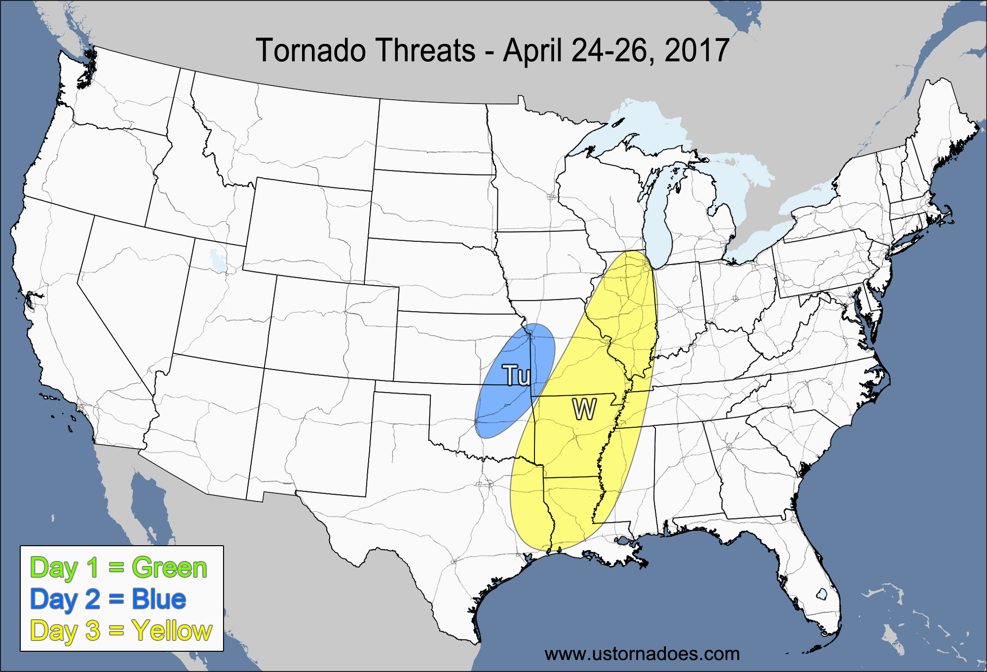
1-3 Day
No tornadoes expected.
Tuesday – Eastern Oklahoma, eastern Kansas, western Arkansas
NUMBER OF TORNADOES EXPECTED: 2-5 – CONFIDENCE: Normal
Tornado Hot-spot: None
Pros: Low to moderate instability, good/excellent speed shear, decent/good low-level directional shear, decent upper-level support.
Cons: Storm mode will quickly go more linear as a cold front forms and organizes most of the storm activity, mostly unidirectional winds in the mid-to-upper levels, capping issues in the southernmost areas.
Wednesday – Central and southern Mississippi Valley
NUMBER OF TORNADOES EXPECTED: 3-8 – CONFIDENCE: Low
Tornado Hot-spot: Southern Mississippi Valley
Pros: Low to moderate instability, good/excellent speed shear, good upper-level support.
Cons: Poor/decent directional shear, mostly linear storm mode.
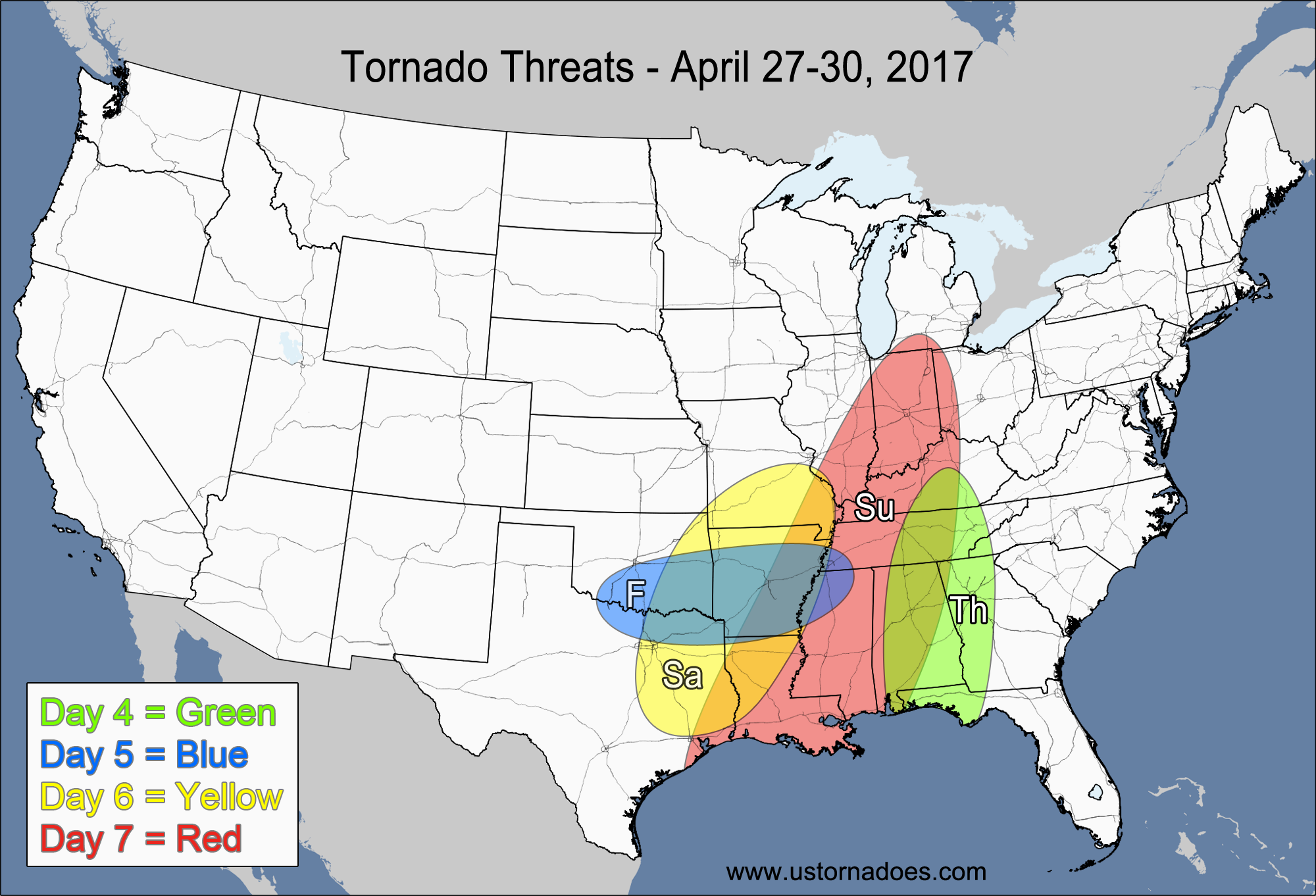
4-7 Day
NUMBER OF TORNADOES EXPECTED: 1-4 – CONFIDENCE: Normal
Tornado Hot-spot: None
Pros: Low to moderate instability, good speed shear.
Cons: Poor/decent directional shear, mostly linear storm mode, fairly weak upper-level dynamics.
Friday – Southern Plains, southern Mississippi Valley
NUMBER OF TORNADOES EXPECTED: 4-10 – CONFIDENCE: Low
Tornado Hot-spot: None
Pros: Moderate to high instability, good/excellent speed shear, decent/good low-level directional shear,
Cons: Questionable storm mode due to mostly unidirectional mid-to-upper level shear, weak upper-level support.
Saturday – Southeastern Plains, southern Mississippi Valley
NUMBER OF TORNADOES EXPECTED: 12-30 – CONFIDENCE: Low
Tornado Hot-spot: None
Pros: Moderate to high instability, good directional shear, good speed shear.
Cons: Somewhat weak upper-level support, uncertainty with the level of instability.
Sunday – Southern Mississippi Valley, Southeast, Ohio Valley
NUMBER OF TORNADOES EXPECTED: 10-25 – CONFIDENCE: Low
Tornado Hot-spot: Southeast
Pros: Good/excellent speed shear, decent/good directional shear, low to moderate instability, decent upper-level support.
Cons: Northern areas face more concerns with low instability and weaker directional shear, the best dynamics (north) are separated from the best instability (south).
Latest posts by Mark Ellinwood (see all)
- Spring 2023 seasonal tornado outlook - March 1, 2023
- Spring 2022 seasonal tornado outlook - March 1, 2022
- Spring 2021 seasonal tornado outlook - March 1, 2021


Stumbled upon this blog a few weeks ago, and now I’m checking it every couple of days or so. I enjoy going through some of the older posts, as well. I didn’t formally study meteorology or atmospheric science (environmental engineer here). As a youngster I was always fascinated by weather, particulrly severe weather, but I never gained much knowledge on the science of weather. In the last few years I’ve become very interested in the topic. I’ve been reading some blogs, watching iTunes U courses, and visiting the Storm Prediction Center’s website fairly often. I need to get my hands on a good general textbook on the topic and go from there I suppose. Anyway, now that I’ve rambled, just wanted to say that the blog is great, and is now part of my routine, ha. Keep it up!
So glad to hear that our site is helping to fuel your interest in weather! Watching thunderstorms and severe weather way back in the day is what got me interested in weather as well.
A couple of the most common textbooks used in early meteorology courses are Meteorology Today (Ahrens) and Atmospheric Science: An Introductory Survey (Wallace & Hobbs). Those would be a good starting point in textbook learning.
Thanks for the suggestions!