Spring is chugging along as the calendar moves into the end of May. Like the previous month’s tornado outlook, we will start here by assessing the month of May before we look ahead to June.
During the first six days of May, there were only two confirmed tornadoes. Although this seems oddly low, it is not at all uncommon to see a lull in tornado activity during the first week of May.
[Early May tends to be feast or famine for tornadoes]
There was an active string of tornado days from May 7-10 [May 9, 2016 tornado outbreak], a localized event in the southern High Plains on May 16, and then a general increase in severe weather as we close the month. Otherwise, the month has been well below average in terms of tornadoes.
The continued lack of a high pressure ridge across the southeastern portion of the country has been a big player in the slow tornado season. This, when coupled with dips of low pressure in the Northeast, which have not been handled particularly well with the long-range ensembles, has prevented any significant tornado events from being able to occur across the central United States.
Changes do appear to be on the horizon into late May. As the larger scale weather pattern shifts, model forecasts are in strong agreement that high pressure returns to the South and East into the final week of the month. With a series of low pressure systems expected to eject from the Rockies into the Plains, multiple tornado events can be expected before May comes to a close. We already saw one on May 22.
Even with activity forecast to pick up, it appears likely that May finishes below average for tornadoes.
The meat
Odds favor the U.S. tornado count to be somewhat below the average of 186 tornadoes (1986-2015 average) for May. Note that the NCDC 1991-2010 average is 243.
Below average: 50% (less than 180 tornadoes)
Near average: 30% (between 180 and 230 tornadoes)
Above average: 20% (more than 230 tornadoes)
The details
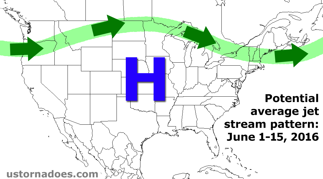
For the month of June, there is mixed news when it comes to tornado prospects. Climatology tells us that it doesn’t take much for tornado activity in June, as the jet stream shifts north and quality moisture often overspreads a large portion of the central states. The drawback is that this June may see “too much” high pressure ridging to take full advantage of the time of year.
[2016 seasonal tornado outlook | May 2016 tornado outlook]
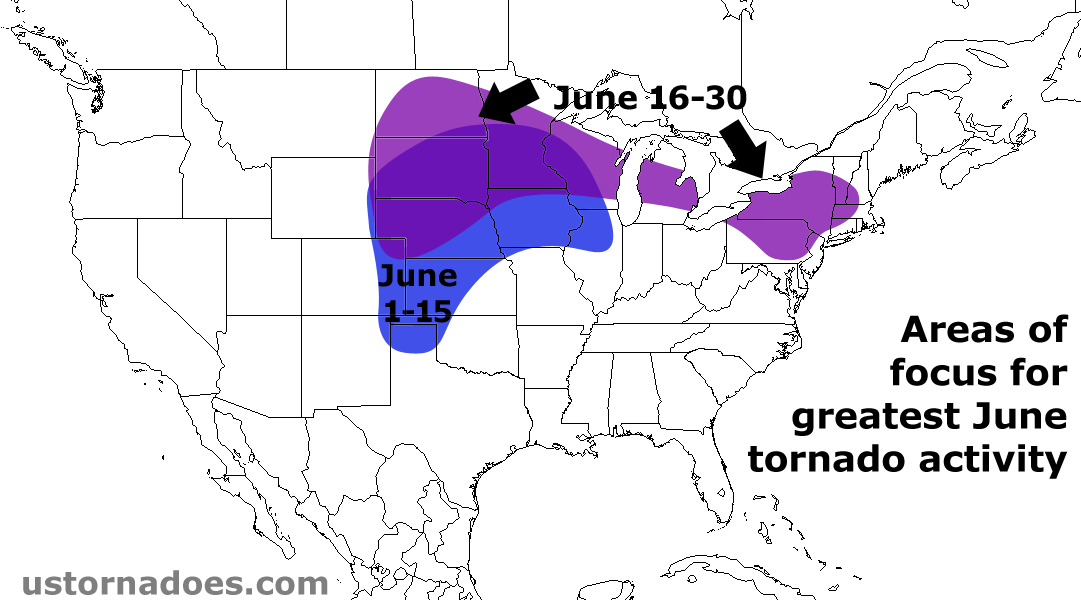
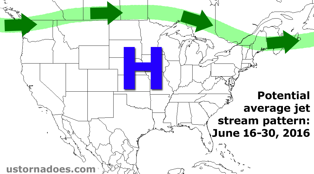
Starting with the first half of the month, there is a growing consensus for considerable high pressure ridging across much of the country. This scenario would work to displace tornado activity up into the central to northern Plains and Upper Midwest. There is a general consensus with analogs to keep the High Plains active in June and this seems more probable early in the month than late in the month.
Also, if ridging is as robust as the longer term models suggest, there may be a lack of consistent and/or higher-end tornado events, instead favoring a more sporadic pattern. A relative lull in tornado activity compared to average is expected during the first week or so of June.
There has been an undeniable bias in the models to be too aggressive with high pressure ridging into the Northeast and both ECMWF and GFS-based analogs do hint at some residual troughing of low pressure affecting the Northeast, at times.
[How does El Nino, La Nina or La Nada impact the following tornado season?]
This pattern would yield bouts of a west-northwest to northwest flow of the jet stream into the Great Lakes and Northeast. Such a pattern has been associated with enhanced tornado activity in the region, especially given the potential for disturbances to drop southeast from Canada with stronger winds aloft and very warm and unstable air in place near the surface. Some of the stronger tornadoes observed in the northeastern U.S. have occurred during a northwest flow regime.
Despite possibly above average tornado activity in the Northeast, ridging across the central states and weaker winds (less wind shear) in the mid and upper levels of the atmosphere will probably limit tornado activity through much of the month from the southern and central Plains into the middle Mississippi Valley.
Analogs show quite a bit of High Plains tornadoes activity, even down into West Texas, but due to significant high pressure ridging, it seems likely that the southern High Plains also quiets down, which aligns closer to climatology. The net result appears to be near to slightly below average tornado counts for mid to late June.
Disclaimer and note: Long term forecasts are educated predictions based on a number of considerations, including computer model forecasts, historical patterns and recent trends. They are intended to give a general idea of what is expected to take place in the coming weeks, but are not flawless and may have limited skill. These broad outlooks cannot account for small scale events or deviations from the projected weather patterns. The bottom line is that it is always a good idea to routinely check the most updated weather forecasts for the latest information.
*I used NCDC’s 1991-2010 average last month, but upon compiling data for the Tracking the tornadoes of 2016 project, I sifted through the last three decades of tornado information to make a 30-year average. This smooths out some of the very active years, like 2008 and 2011 (and the absurdly active April of 2011), but doesn’t go too far back in order to avoid the early years, like the 1950s, 60s and 70s, when countless tornadoes may have never been surveyed or even discovered.
Latest posts by Quincy Vagell (see all)
- How peak tornado season ends up active or quiet in the Plains - May 14, 2019
- Low tornado count set to continue through the end of April, but it’s too early to call the season - April 21, 2018
- June 2016 tornado outlook - May 23, 2016
