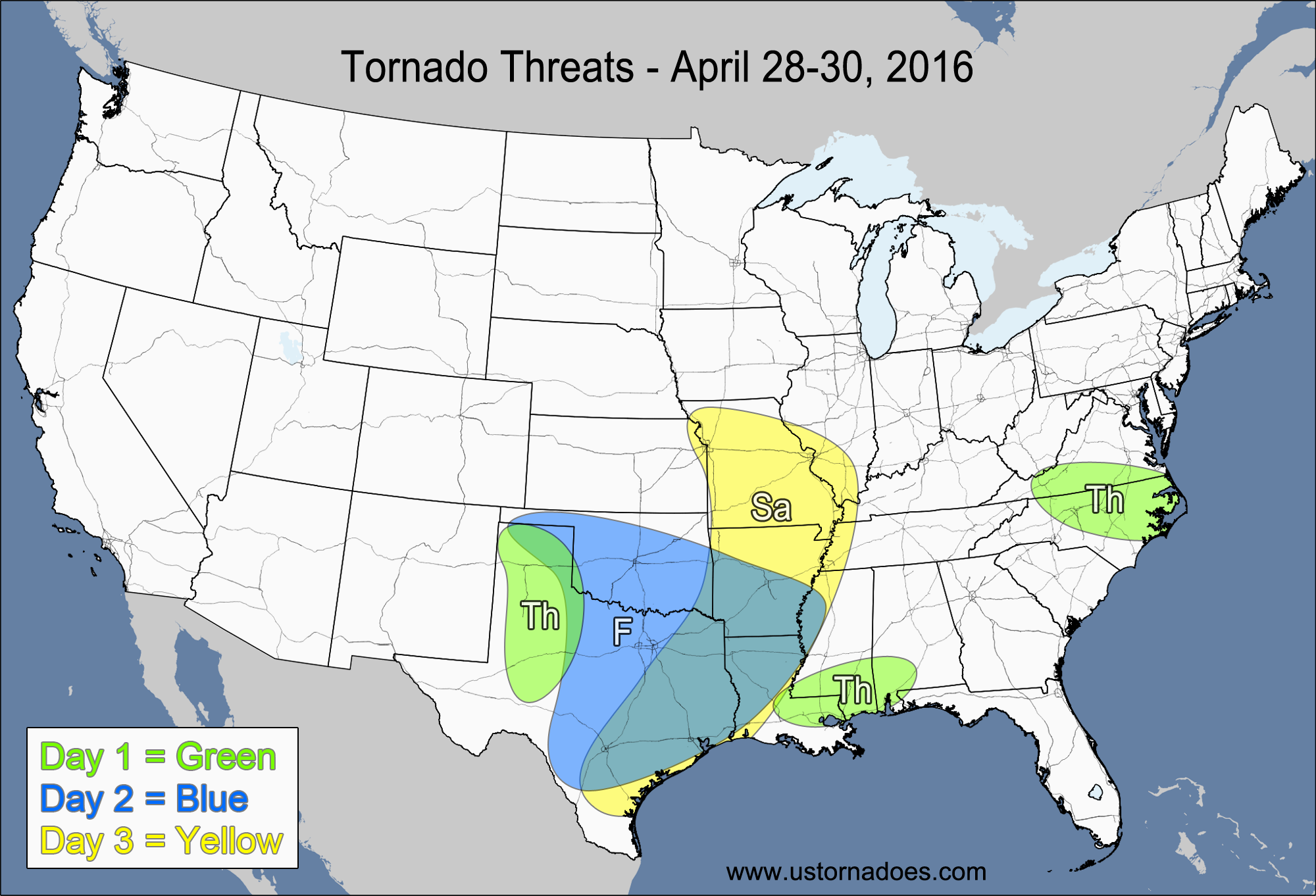
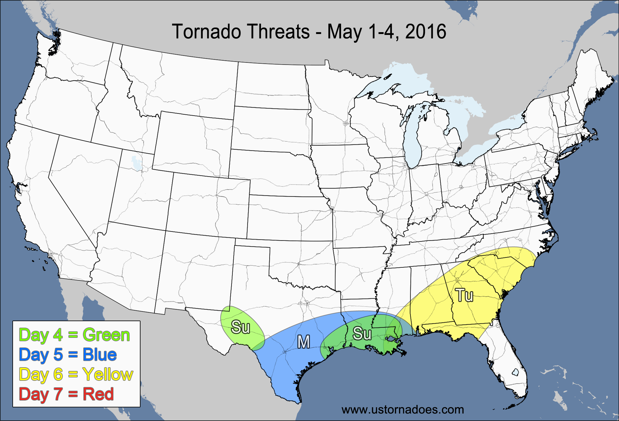
Tuesday’s severe weather outbreak just squeaked in to the lower threshold we had for that day, with several tornadoes being outside of our main risk area. Not the best verification for the first “bigger” severe day of the spring, but decent nonetheless. Those crazy veer-back-veer wind profiles did a lot to keep the overall tornado threat toward the low side of the system’s overall potential.
The main threat for the next seven days will be Friday into Saturday, with very little activity expected during the first half of next week.
1-3 Day
NUMBER OF TORNADOES EXPECTED: 1-3 – CONFIDENCE: High
Tornado Hot-spot: None
Pros: Low-to-moderate instability, good speed shear, good low-level directional shear.
Cons: Questionable storm coverage, mid-level lapse rates aren’t that good, upper-level dynamics haven’t reached the Plains yet.
Thursday – Southern Louisiana, southern Mississippi, southern Alabama
NUMBER OF TORNADOES EXPECTED: 0-1 – CONFIDENCE: High
Tornado Hot-spot: None
Pros: Low-to-moderate instability, decent/good low-level directional shear, potential for random outflow boundary interactions.
Cons: Poor speed shear, unidirectional winds in the mid-to-upper levels, poor/decent mid-level lapse rates, no upper-level support.
Thursday – North Carolina, southern Virginia
NUMBER OF TORNADOES EXPECTED: 0-1 – CONFIDENCE: High
Tornado Hot-spot: None
Pros: Low-to-moderate instability, decent/good low-level directional shear.
Cons: Poor/decent speed shear, unidirectional winds in the mid-to-upper levels, poor/decent mid-level lapse rates, no upper-level support.
Friday – Southern Plains, southern Mississippi Valley
NUMBER OF TORNADOES EXPECTED: 6-16 – CONFIDENCE: Normal
Tornado Hot-spot: Oklahoma, northern Texas
Pros: Good/excellent low-level directional shear, good speed shear, low-to-moderate instability, decent/good upper-level dynamics.
Cons: Mostly unidirectional winds in the mid-to-upper levels, storms may cluster and become linear fairly quickly, potential capping/lapse rate issues in the southern Mississippi Valley.
Saturday – Southeastern Plains, central and southern Mississippi Valley
NUMBER OF TORNADOES EXPECTED: 3-8 – CONFIDENCE: Normal
Tornado Hot-spot: None
Pros: Moderate instability, decent/good speed shear, decent upper-level dynamic support in the northern parts of the risk area.
Cons: Poor/decent directional shear, mostly linear storm mode, poor upper-level dynamic support in the southern parts of the risk area.
4-7 Day
NUMBER OF TORNADOES EXPECTED: 0-2 – CONFIDENCE: High
Tornado Hot-spot: None
Pros: Good directional shear, decent/good speed shear.
Cons: Low instability, main upper-level forcing is too far west still, very limited area of potential.
Sunday – Western Gulf Coast
NUMBER OF TORNADOES EXPECTED: 0-3 – CONFIDENCE: Normal
Tornado Hot-spot: None
Pros: Good low-level directional shear, low-to-moderate instability.
Cons: Weak low-to-mid level speed shear, poor/decent mid-level lapse rates, little upper-level support.
Monday – Southern Texas, Louisiana, southern Mississippi
NUMBER OF TORNADOES EXPECTED: 0-3 – CONFIDENCE: Low
Tornado Hot-spot: None
Pros: Good directional shear, low-to-moderate instability.
Cons: Weak low-level speed shear, questionable lapse rates, messy storm mode, little upper-level dynamic support.
Tuesday – Southeast
NUMBER OF TORNADOES EXPECTED: 0-3 – CONFIDENCE: Low
Tornado Hot-spot: None
Pros: Low-to-moderate instability and decent speed shear and upper-level dynamics, as shown on the ECMWF model only.
Cons: No support from the GFS model, which only has a weak reflection of a disturbance with little to no instability and much weaker dynamics.
Wednesday
No tornadoes expected.
Latest posts by Mark Ellinwood (see all)
- Spring 2023 seasonal tornado outlook - March 1, 2023
- Spring 2022 seasonal tornado outlook - March 1, 2022
- Spring 2021 seasonal tornado outlook - March 1, 2021


