April will soon be coming to a close, so it’s time to look ahead at what May might have in store in terms of tornadoes across the United States. This is our second monthly tornado outlook here and before looking ahead, it’s a good time to take a step back and first consider how the April outlook is verifying.
As predicted in the April tornado outlook, the first half of the month was relatively slow with tornado activity, particularly due to a tendency for low pressure to find a home across the northeastern United States. This kept most of the warm and unstable air (favorable for tornadoes) suppressed over the Southeast. The April outlook called for a significant pattern change around the middle of the month, favoring an active second half. While this pattern change is still likely, the pattern shift is seemingly delayed about 7-10 days from the thinking this time last month.
Tornado activity is expected to really pick up next week, the final week of April, as a ridge of high pressure builds in the East and a series of low pressure systems swing out of the West Coast and Rockies. With that said, the delayed pattern change means that the slower-than-average pattern persisted longer than expected, which may result in tornado counts in April finishing a bit below expectations. Once the final numbers for April are counted, I will conduct a review in early May to give a final “grading” of the first monthly tornado outlook.
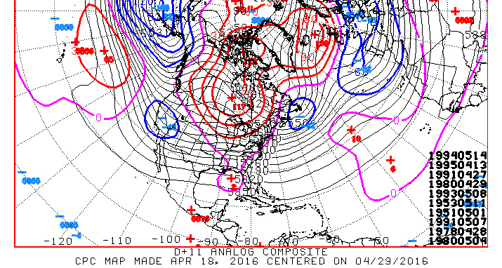
Nonetheless, in the midst of a pattern change, one that favors an increase in tornado activity, it is looking like the peak tornado season may finally be getting underway as we close out April.
May is generally considered the peak month of the season as tornado frequency picks up on a regular basis and the region favored to see the most tornadoes shifts toward the nation’s heartland. While this May is not expected to be as busy as last May, when 381 tornadoes occurred, the forecast does call for a fairly active month, which is a big change from the relative dearth of activity that April started off with.
The meat
Odds favor the U.S. tornado count to be fairly close to the average of 254 tornadoes (1986-2015 average) for May. Note that the NCDC 1991-2010 average is 276.
Below average: 20% (less than 240 tornadoes)
Near average: 50% (between 240 and 290 tornadoes)
Above average: 30% (more than 290 tornadoes)
The details
The progression of the jet stream through spring helps transport warm, unstable air farther north in the heart of spring, so it’s not just confined to the Gulf Coast region as we generally see through much of the winter and early spring. Our eyes then shift out west and look for storm systems to develop over the Rockies and “eject” east, often resulting in textbook tornado setups. Of course, there are other ways that tornadoes can form, but this is how peak season likes to deliver.
[2016 seasonal tornado outlook | April 2016 tornado outlook]
The extended computer forecast ensembles indicate that a favorable pattern in late April could spill over into at least the first few days of May. This is supported by a number of analogs (similar weather patterns from the past), including 2008, which was also used in the April tornado outlook.
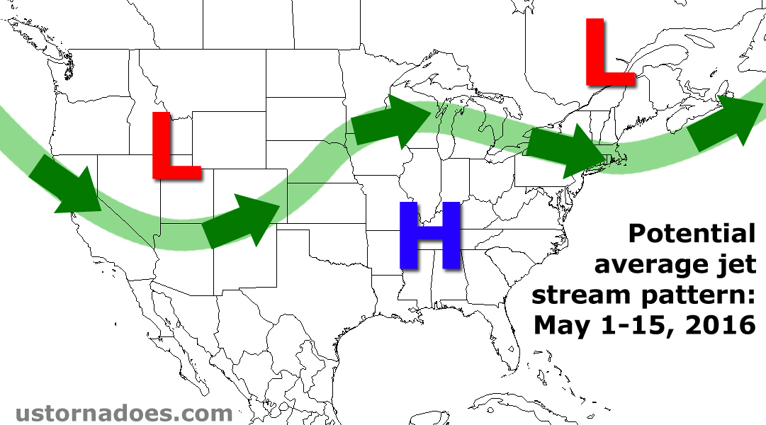
One thing learned from regular watching of the computer models is that they have had a high pressure bias lately, meaning a tendency to blow up a big ridge of high pressure over North America and the hemisphere as a whole. Instead of completely eroding a trough of low pressure over southeastern Canada, the models are finally showing some hints of this feature lingering into early May. This is supported by a multi-model consensus and trends from the past few weeks.
What does this all mean for the first half of May?
Well, troughs of low pressure are still favored across the western half of the U.S. during the first week of May, with storm systems forecast to dive from the Rockies into the central Plains. States like Texas and Oklahoma are favored for the most tornado activity and the month could easily get off to a fast start. Toward the second week of May, the jet stream is expected to move into a more zonal orientation, allowing for tornado threats to fill north a bit into the central Plains toward the Midwest. Overall, the first half of May is expected to follow close to average for tornadoes, with perhaps a few particularly busy days at the very start of May.
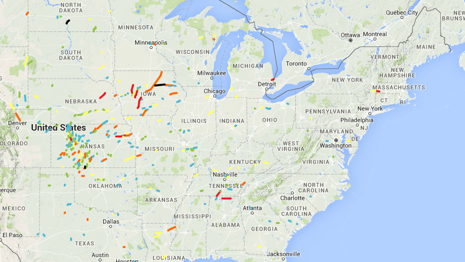
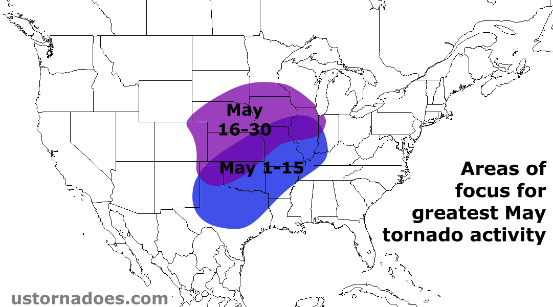
A common theme from several of the analogs derived from the European ensembles (EPS) and GFS ensembles (GEFS) is two distinct camps of tornado activity in May.
The initial cluster is tightly packed from North Texas into Oklahoma. As the month goes on, another cluster shows up from Kansas/Nebraska into Iowa. While May is known for being a huge month in Kansas, states like Nebraska and Iowa typically don’t reach peak tornado season until June.
[Where tornadoes typically form in May | Where tornadoes typically form in June]
The pattern suggests that parts of the Northeast could see a slow start to their respective tornado season, especially if the “dreaded” trough of low pressure across southeast Canada tries to nose into the region.
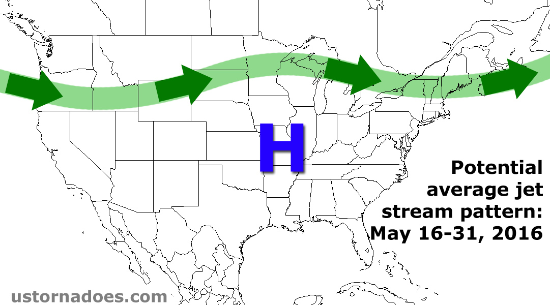
In general, near average tornado activity is also expected for the U.S. as a whole for the second half of May, as a more zonal flow could work to mitigate the high-end tornado outbreak potential just a bit.
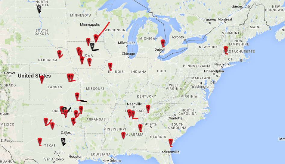
Since I am skeptical about the amount of high pressure ridging across the U.S., the thinking for the latter portion of the month follows a compromise between ensemble forecasts and the analogs. The analogs, which include 1951, 1953, 1954, 1960, 1991, 1994, 1995 and 2008 (top 5 EPS-based and top 3 GEFS-based analogs), show quite a bit of variability through May.
[May tornadoes, Strong May tornadoes, May tornado locations]
Some had below average activity to finish the month, while a few others remained fairly active. This is another reason why I am hedging my bets with a near average May.
Another interesting note is that there were several violent (E/EF4 and even E/EF5) tornadoes in these analogs. Then again, we’re off to a pretty slow start on that angle, so we are arguably due a few. The bottom line is that although this May is forecast to be “near normal” for tornadoes, the potential will be there for a couple of higher-end tornado events. After all, May is no stranger to significant tornado outbreaks.
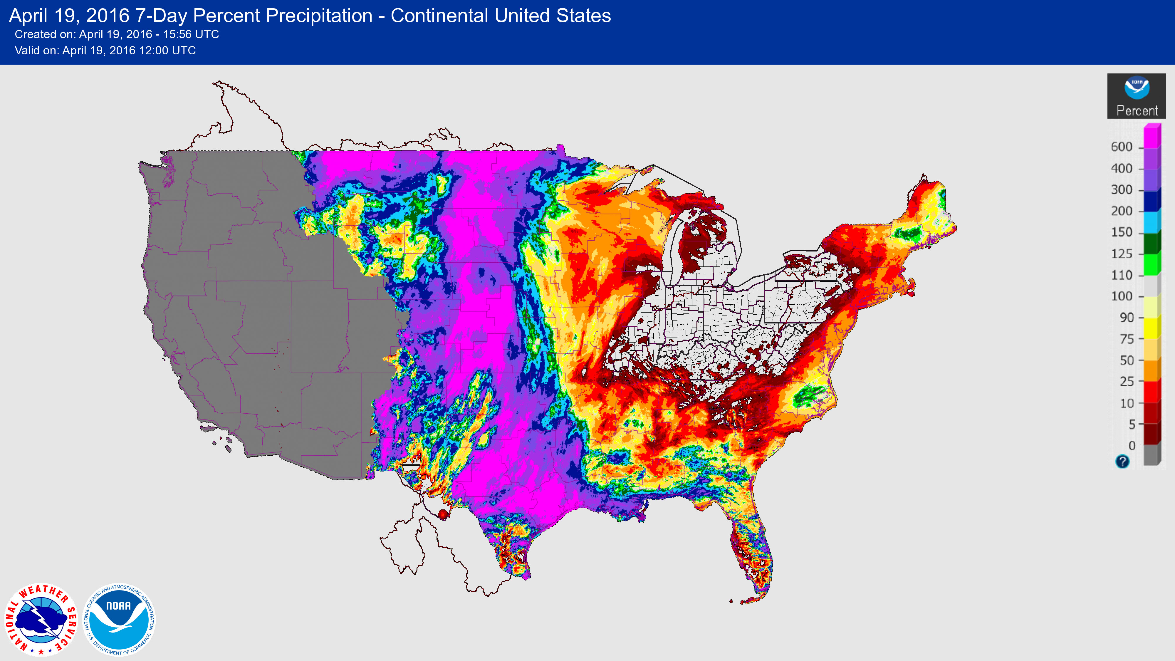
Another good sign for May if you’re looking for tornadoes is all of the recent rainfall across the Plains.
[Mod-Strong El Nino tends to favor a tornado season peak in May and June]
Going into April, a short-term drought was worsening across parts of the High Plains. Rain in mid-April has helped alleviate the concern of parched soil and lackluster low-level moisture across parts of this region. In Texas, much like last spring, north, east and coastal parts of the Lone Star State are being inundated with excessive rainfall.
Considering that moisture trajectories in typical Plains severe weather events will flow from the Gulf of Mexico across this part of Texas, this is another encouraging factor that should aid in moisture transport across the Plains this May. This continues the theme of 2015, which saw a sudden shift away from the dry and widely considered poor tornado chase seasons in the springs of 2013 and 2014.
As mentioned, look for a complete recap of the April tornado outlook coming up in early May. These outlooks will continue to be refined as they are done and we better learn what works and what doesn’t.
Disclaimer and note: Long term forecasts are educated predictions based on a number of considerations, including computer model forecasts, historical patterns and recent trends. They are intended to give a general idea of what is expected to take place in the coming weeks, but are not flawless and may have limited skill. These broad outlooks cannot account for small scale events or deviations from the projected weather patterns. The bottom line is that it is always a good idea to routinely check the most updated weather forecasts for the latest information.
*I used NCDC’s 1991-2010 average last month, but upon compiling data for the Tracking the tornadoes of 2016 project, I sifted through the last three decades of tornado information to make a 30-year average. This smooths out some of the very active years, like 2008 and 2011 (and the absurdly active April of 2011), but doesn’t go too far back in order to avoid the early years, like the 1950s, 60s and 70s, when countless tornadoes may have never been surveyed or even discovered.
Latest posts by Quincy Vagell (see all)
- How peak tornado season ends up active or quiet in the Plains - May 14, 2019
- Low tornado count set to continue through the end of April, but it’s too early to call the season - April 21, 2018
- June 2016 tornado outlook - May 23, 2016
great information. highly educated, thank you for your great knowledge.