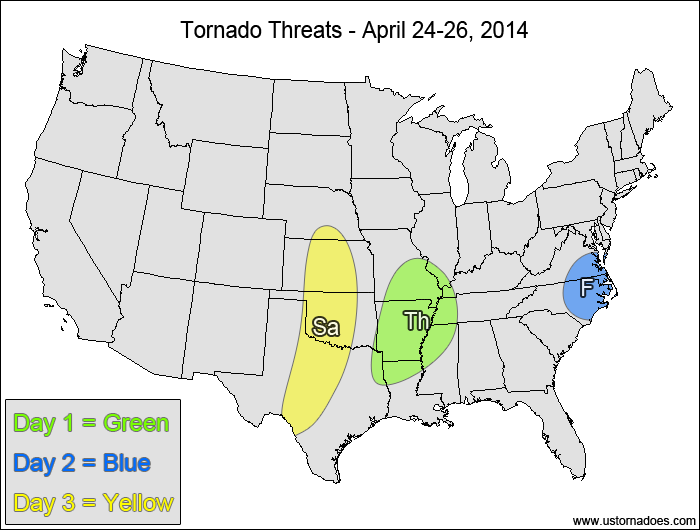
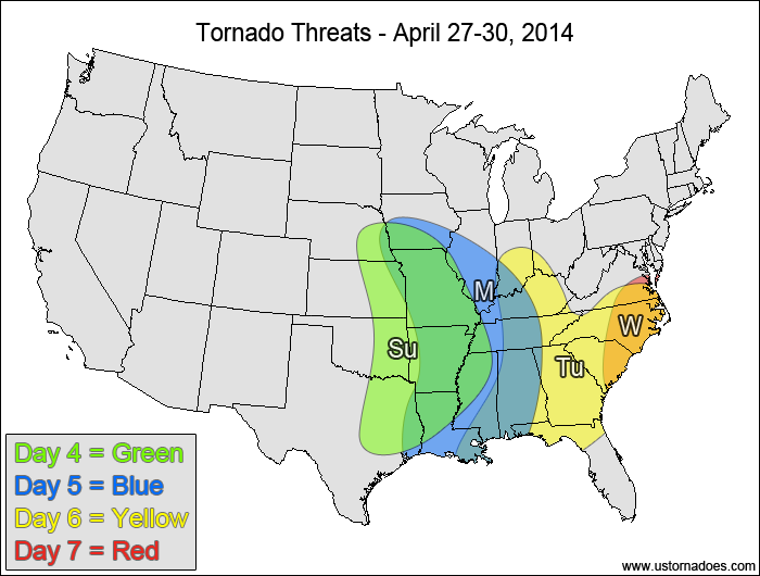
4/26 8:30pm EDT UPDATE: The tornado ingredients seem to be coming together better for the Sunday through Wednesday period. We will have a special update outlining this potential Sunday morning.
—–
The first real severe weather outbreak of the season starts Saturday (or Sunday if storms don’t really get going on Saturday) and will continue through the first half of next week. Some tornadoes are expected with it, but some uncertainties keep the upside/downside potential fairly equal overall, though the upside potential may be more favored Sunday through Tuesday if the storm evolution gets better.
Mid/Southern Mississippi Valley — TORNADO RANGE: 0-2 — CONFIDENCE: High
Expected Tornado Hotspot: None
Pros: Good speed shear and upper-level forcing, low to moderate instability
Cons: Weak directional shear, mostly linear storm mode, weak mid-level lapse rates
Friday
Eastern North Carolina, eastern Virginia — TORNADO RANGE: 0-2 — CONFIDENCE: High
Expected Tornado Hotspot: None
Pros: Good directional shear, decent speed shear, good upper-level forcing
Cons: Low instability, limited afternoon heating after warm front and rain passage, storm coverage concerns once the more favorable atmosphere develops
Saturday
Central and southern Plains — TORNADO RANGE: 1-5 — CONFIDENCE: Normal
Expected Tornado Hotspot: Central Texas to central Oklahoma
Pros: Moderate to high instability, good directional and speed shear, well-defined dry line boundary for storm initiation, some upside potential if several long-lasting supercells can develop
Cons: Initially high LCLs, upper-level dynamic forcing arrives late and could limit storm coverage, upper-level winds become more southerly in the late evening/overnight hours
East-central and southeastern Plains, central and southern Mississippi Valley — TORNADO RANGE: 4-12 — CONFIDENCE: Normal
Expected Tornado Hotspot: East-central Plains to mid-Mississippi Valley
Pros: Strong speed shear, good directional shear, good upper-level forcing, low to moderate instability
Cons: Mostly unidirectional shear aloft in the southern areas, backing upper-level winds in the northern parts of the risk area, pre-frontal capping could limit potential for supercells ahead of the main line of storms, storms with best forcing may become linear quickly
Monday
Mid and southern Mississippi Valley, western Southeast — TORNADO RANGE: 2-7 — CONFIDENCE: Normal
Expected Tornado Hotspot: Mid-Mississippi Valley
Pros: Good speed shear, decent/good directional shear, moderate instability in the southern areas, good upper-level forcing in the northern areas
Cons: Upper-level forcing to the north starting to separate from the best instability to the south, low instability and mostly unidirectional shear aloft in the northern parts of the risk area
Tuesday
Tennessee Valley, Southeast — TORNADO RANGE: 2-6 — CONFIDENCE: Low
Expected Tornado Hotspot: None
Pros: Good speed shear, decent/good directional shear in the southern areas, good/strong upper-level dynamics, low to moderate instability in the southern areas
Cons: Low instability except in the western Southeast, storms in best environment may line out quickly, unidirectional shear aloft in the northern parts of the risk area
Wednesday
Carolinas, southern Virginia — TORNADO RANGE: 0-3 — CONFIDENCE: Low
Expected Tornado Hotspot: None
Pros: Good speed shear, decent/good low-level directional shear, good upper-level forcing
Cons: Low instability, unidirectional shear aloft could line storms out early
Latest posts by Mark Ellinwood (see all)
- Spring 2023 seasonal tornado outlook - March 1, 2023
- Spring 2022 seasonal tornado outlook - March 1, 2022
- Spring 2021 seasonal tornado outlook - March 1, 2021


