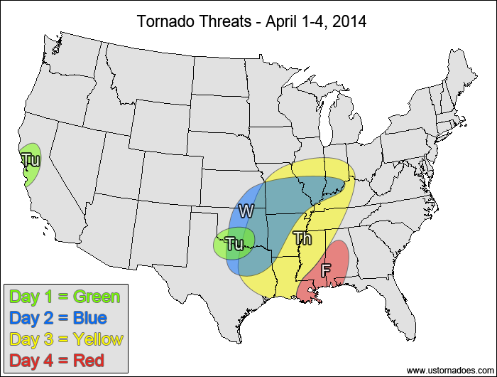
It’s 2014, and we have a couple of changes to the format of the Tornado Threat Forecasts. There may be some additional tweaks as we get settled into the 2014 tornado season. Firstly, the Tornado Potential, which was just a gauge of how many tornadoes to expect, will be replaced with an actual tornado range, since that’s just basically what the Tornado Potential was, anyway. Forecasting an actual range once you get above several tornadoes can be pretty difficult, so the Forecast Confidence and the text discussion will balance how likely I think that the actual tornado count will fit within the given range. A wider range may also hint at the amount of uncertainty in the forecast.
Sometimes there will be a large risk area, but most tornadoes will be concentrated in a certain part of it. To help give more detail to the forecast, we have added the Expected Tornado Hotspot for where tornadoes will be most likely and/or most numerous.
(Note: This is not an April Fool’s joke… I blame the bad timing of the more active weather pattern.)
North-central Texas, southern Oklahoma — TORNADO RANGE: 0-3 — CONFIDENCE: Normal
Expected Tornado Hotspot: None
Pros: Moderate instability, strong directional shear, good speed shear
Cons: Strong capping inversion leading to questionable storm coverage
California — TORNADO RANGE: 0-2 — CONFIDENCE: High
Expected Tornado Hotspot: None
Pros: Good upper-level forcing, strong directional shear
Cons: Low instability, weak speed shear in the low to mid levels
Wednesday
Central/southern Plains, mid-Mississippi Valley — TORNADO RANGE: 3-10 — CONFIDENCE: Normal
Expected Tornado Hotspot: Central and eastern Oklahoma, western Missouri
Pros: Moderate to high instability, good/strong speed and directional shear, upside risks if more discrete storms can develop within the area(s) with the best environment
Cons: Weak to moderate mid-level capping inversion could limit storm coverage, main upper-level forcing is still well west of the risk area, rising heights across much of the risk area, questionable storm mode/intensity away from the highest risk areas
Thursday
Southeastern Plains, lower and mid-Mississippi Valley, Tennessee Valley — TORNADO RANGE: 8-15 — CONFIDENCE: Normal
Expected Tornado Hotspot: Mid-Mississippi Valley
Pros: Moderate instability, good upper-level dynamics, good speed shear, okay/good directional shear, deepening and progressive surface low
Cons: Ongoing convection in the warm sector during the morning and afternoon hours could inhibit the potential, surface low may initially be strung out through the afternoon and possibly into the early evening, some models show more unidirectional shear aloft
Friday
Western Southeast — TORNADO RANGE: 0-3 — CONFIDENCE: Normal
Expected Tornado Hotspot: None
Pros: Ongoing storms in the morning could hold onto enough directional shear with low to moderate instability to produce tornadoes
Cons: Weak directional shear, narrow band of decent instability, mostly a morning threat, main dynamics are displaced well to the north
Latest posts by Mark Ellinwood (see all)
- Spring 2023 seasonal tornado outlook - March 1, 2023
- Spring 2022 seasonal tornado outlook - March 1, 2022
- Spring 2021 seasonal tornado outlook - March 1, 2021


I like your forecast as they explain severe weather ingredients to the uninformed, like myself, unlike reading mesoscale disscustions, which can be confusing. Such as whether or not capping is a nonconductive to tornadoes. Thank you for your wonderful research and website!