We have made it through another meteorological winter, though it may not seem like it east of the Rockies for a while longer. With meteorological spring right around the corner (March, April and May), it is time once again to inspect the long range forecast to try to infer how active the spring tornado season may be.
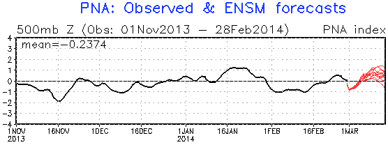
For March, we are able to use more of the traditional medium and long range tools like the Pacific-North American Pattern (PNA) and the Western Pacific Oscillation (WPO) in addition to the more seasonal signals like ENSO, PDO and AMO, many of which I referenced in last year’s spring tornado outlook. The two most commonly referenced global forecast models, the GFS (American model) and ECMWF (European model, or Euro), help paint the picture on how the first half of March will turn out.
In the near term, there is a low tornado threat in the South, but weak low-level and mid-level lapse rates will inhibit tornado development.
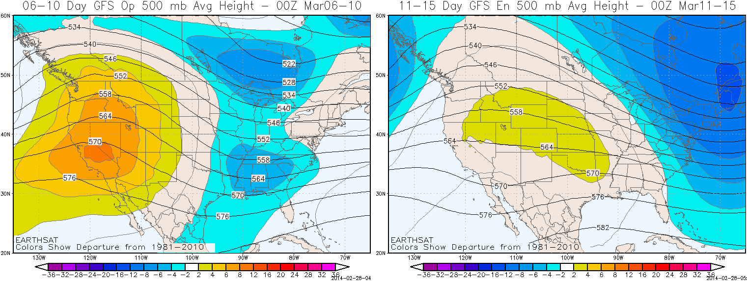
These images of anomalies in the upper-atmosphere help show the general weather pattern we could expect to see during the 6-10 day and 11-15 day forecast periods, which will take us through about the first half of the month. The higher than normal anomalies over the western U.S. represents upper-level ridging, which is typically associated with drier and warmer than normal weather at the surface. The lower than normal heights over the eastern U.S. and eastern Canada is upper-level troughing, which typically produces unsettled weather south and east of the core of the trough in the mid-latitudes of the Northern Hemisphere. Ridging over the western U.S. and troughing over the eastern U.S. is a fairly stable pattern for most of the country, with winds predominately out of the northwest bringing cold, dry Canadian air into the U.S. This northwesterly flow also prevents the transport of warm, moist Gulf of Mexico air into the country. Without ample Gulf moisture, the odds of getting tornadoes are pretty low in March.
The best bet for getting tornadoes this March will probably be from cut-off lows undercutting the upper-level ridge in the western U.S., which would bring disturbances over the Southwest before ejecting into the Plains. This near-term event that will bring much needed precipitation to California is not expected to bring that much tornado activity east of the Rockies because the main upper-level trough to the north of it will interfere and disrupt the storm’s upper-level energy, which limits how well the disturbance will be able to develop once it pushes into the Plains. With the predominant pattern of a ridge in the West and trough in the East that is forecast to last through at least the first half of March, I expect the month as a whole to be quieter than normal. The GFS and ECMWF models suggest that we have a +PNA signal beyond mid-month, which would help keep tornado activity low. However, the rise of the WPO signal towards positive levels mid-month may provide the opportunity for more disturbances to work into the Southwest in the middle to later parts of the month.
For April and May, we must fall back more to the El Niño-Southern Oscillation (ENSO) and other longer range signals to determine how these months could end up.
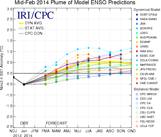
Unfortunately, ENSO is not really going to give us much help with determining the seasonal forecast as it lacks any sort of notable positive (El Niño) or negative (La Niña) tendencies through spring. The forecast trends the signal in the positive direction through spring, but it remains in neutral territory while doing so. Since we cannot reliably use ENSO as a major driver of the U.S. weather pattern, we must utilize some other long range predictors.
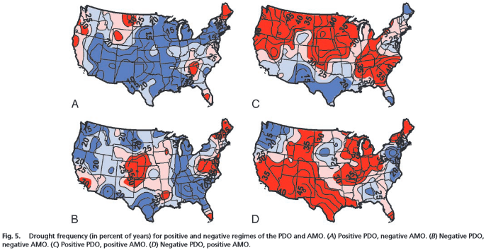
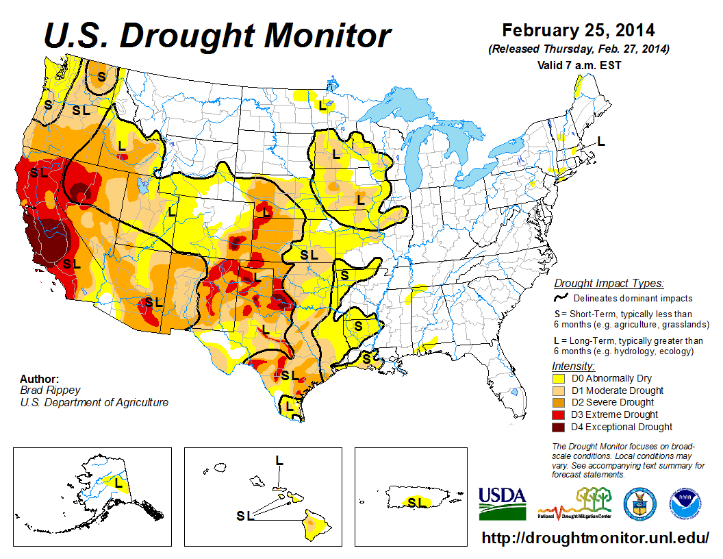
The predominant Pacific Decadal Oscillation (PDO) in recent years has been negative while the Atlantic Multidecadal Oscillation (AMO) has been mostly positive. There have been recent blips in both indices that have taken the PDO to weakly positive levels and the AMO to weakly negative levels in January, but I expect both to return to their long-term anomalies of -PDO and +AMO for the spring. This -PDO/+AMO is shown to have higher drought frequency over the Southwest, Rockies and southern Plains, which would argue that the current drought these areas are in would most likely persist into this spring.
Persistence and/or worsening of the drought over the southwestern U.S. and southern Plains will generally help raise low level temperatures and decrease low-level moisture, which may lead to a northern shift in the storm track that would work to separate storm systems from the Gulf moisture.
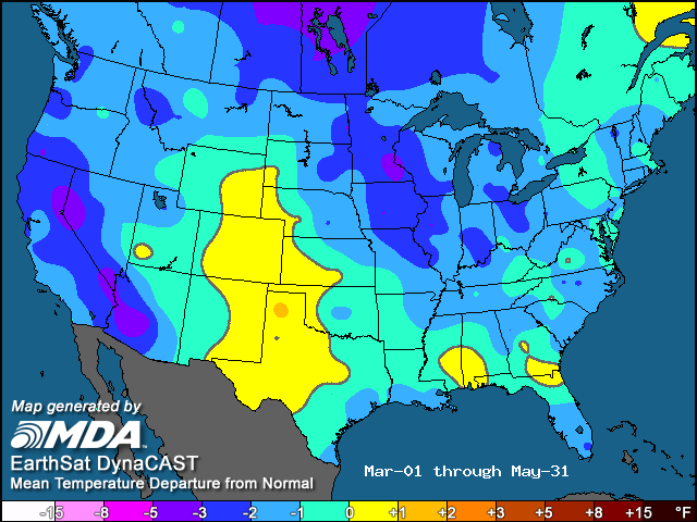
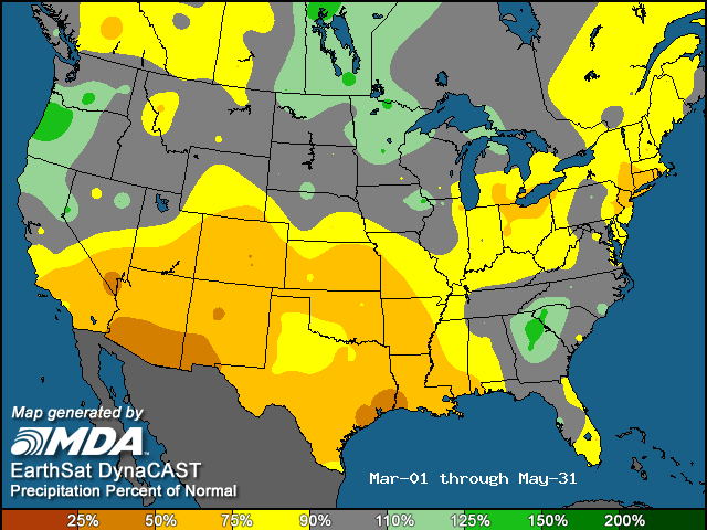
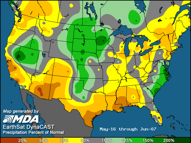
My strongest analogs for this spring come from the early 1960s, which was also a time of -PDO/+AMO in addition to a multi-year weak ENSO signal, with my three primary years being 1960, 1962 and 1963. The average of these three years results in the following temperature and precipitation anomalies for meteorological spring:
These combined with the recent long-term pattern of warmer temperatures in the West and colder anomalies from the Plains to the East Coast reveals a pattern that is unfavorable for tornadic systems.
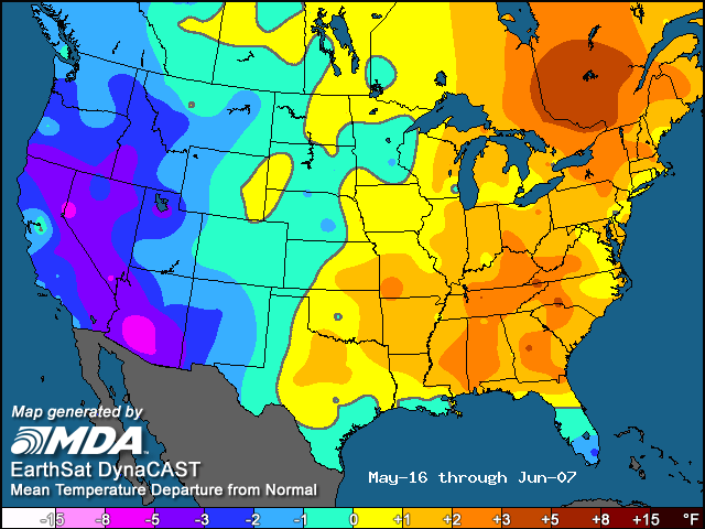
One intriguing caveat to the forecast that may not necessarily verify but is interesting to note is the somewhat favorable pattern these analogs have during the core of chase season, from the back half of May into the first week of June. The colder west/warmer east temperature gradient over the central U.S. along with wetter than normal conditions in most of the northern and central Plains hints that the heart of tornado season could be more active than normal. I would not hang my hat on this period becoming more active as the analogs may indicate, but it does provide some hope to chasers.
Bottom line…
I expect a quieter than normal spring, with potential upside risks if we can see more of a split flow pattern (as opposed to a stout ridge in the West/trough in the East pattern) in which storms can traverse over the Southwest and undercut the predominant upper-level ridging over the western U.S.
Odds of the tornado count ending up below/near/above normal for meteorological spring:
Below normal: 50%
Near normal: 30%
Above normal: 20%
Long term forecasts, while generally providing added value to climatology, are still very broad-brush outlooks and do not offer a very consistent level of skill. This forecast only hopes to capture some of the most reliable information available to provide a best guess as to what spring may bring.
Latest posts by Mark Ellinwood (see all)
- Spring 2023 seasonal tornado outlook - March 1, 2023
- Spring 2022 seasonal tornado outlook - March 1, 2022
- Spring 2021 seasonal tornado outlook - March 1, 2021
Well, this may not be the good news that severe weather junkies, armchair meteorologists, and storm chasers were hoping for, however your detailed & well-explained predictions are very much appreciated nevertheless!
Also, this is good news for millions of people, as these predictions may mean that residents of Tornado Alley & Dixie Alley may be able to breathe easier during early spring. This will be especially welcomed by residents of Moore, Joplin, and other communities that have suffered immensely at the hands of severe weather and continue to rebuild & heal physical, emotional, and psychological wounds.
A question: Severe weather/tornado season got off to a relatively slow start last year, and overall numbers of tornadoes were relatively low, however it seemed that the days with set-ups favourable for severe weather turned out to produce very violent tornadoes, some of which impacted communities to a terrible degree. The 2013 season seemed to have a “violent or nothing at all” character.
I am wondering if the climatological factors you anticipate for the early & late spring periods in 2014 could promote similar extremes this year, ie. When the blocking pattern breaks down for a short period of time, will the conditions “swing to the far end of the pendulum” and produce exceptionally violent outbreaks of severe weather & tornadoes?
Thanks!
Derek
Derek,
That kind of detail is impossible to tell this far out. With long range forecasts such as this, below/near/above normal is pretty much all you can say with any sort of hope of beating climatology. It’s possible that we could end up like last year, which had mostly localized strong events if and when tornadoes did occur, but I cannot say yes or no without any sort of certainty.
– Mark
Absolutely agree with Derek…. I have never seen so many tornadoes with such strength to produce horizontal vortices as I did last year. The first tornado I witnessed perform this phenomenon was Tuscaloosa in 2011… It seemed like every tornado I witnessed mature last year was so strong that it developed these horizontal vortices. Which, seeing first hand…. takes on the appearance of a pissed off battleship firing missiles. My gut, which very much still means something as a chaser…. is this year will be a carbon copy. Thank you for your in depth report. But unfortunately, I will still be bringing my rescue and first aid gear while chasing this spring.
Well, obviously, your predictions have gone awry for Eastern Nebraska! We had a terrible afternoon and evening yesterday 5-11-2014 and into the wee hours of the a.m. Seems that some small towns were nearly wiped off the map, and others had severe damage, including infrastructure, electricity failures, and flooding. i am not a storm chaser – i don’t find it exhilarating to watch the destruction of people’s lives and property. i have a huge 100+ foot tree laying against the roof of my house with branches poking through my roof. i would be sad to think some storm chaser got “high” watching the storm lay my big ancient tree down on my roof! But, aside from that – your predictions have apparently been just that – predictions predicated on your own interpretation of the science of storm and weather tracking. phooey!