1-3 DAY
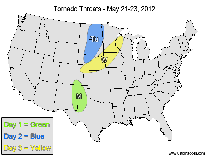
Southern High Plains — POTENTIAL: Low — CONFIDENCE: High
An isolated tornado or two are possible within a low CAPE, low speed shear environment thanks to good low-level directional shear and upslope enhancement. Primary concern will be during the late afternoon and early evening, with little to no tornado risk outside of this time frame.
Tuesday
Northern Plains — POTENTIAL: Low — CONFIDENCE: Normal
Enhanced upper-level dynamics will allow for a low tornado potential in a low/moderate CAPE and moderate shear environment. Dry air in the low-levels will inhibit storm formation and will keep LCLs high during the peak hours. The best chance for tornadoes will be in the northern areas near the triple-point.
Wednesday
Central Plains, western Midwest — POTENTIAL: Medium — CONFIDENCE: Normal
A fairly large cap will be in place across the warm sector, but low to moderate CAPE and shear near a frontal boundary should be enough to trigger at least one tornado-producing storm, with the greatest tornado risk over Nebraska where the highest instability is expected.
4-7 DAY
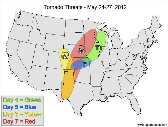
Western Midwest — POTENTIAL: Medium — CONFIDENCE: Normal
Upper-level forcing will strengthen some compared to Wednesday, but lingering issues with the cap and more unidirectional wind profile will inhibit the tornado potential. The latest 12z GFS and NAM do not have much precipitation within the area of the greatest tornado potential, but the more aggressive ECMWF shows greater storm coverage, bringing the potential up to medium.
Friday
Kansas — POTENTIAL: Low — CONFIDENCE: Low
Model agreement starts to wane significantly at this range, with some support for tornado potential south of a lingering frontal boundary in an environment with low to moderate CAPE, low speed shear and good directional shear. The cap remains one of the biggest storm inhibitors within the risk area.
Saturday
Central and southern High Plains — POTENTIAL: Medium — CONFIDENCE: Low
A strong upper-level trough is forecast to develop over the western U.S. on Saturday as a surface low deepens in the central High Plains. This new disturbance will bring moderate to strong shear to the High Plains, but moisture may be lacking, which will inhibit the instability. Discrepancies in the storm coverage and uncertainty in the amount of moisture available will limit the tornado potential and will keep the confidence low.
Sunday
Plains, western Midwest — POTENTIAL: High — CONFIDENCE: Low
The upper-level trough will try to progress eastward into the Plains on Sunday, and although the trough will weaken as it tries to work into a strong ridge settled over the eastern U.S., it will bring enough shear and dynamics to provide a medium to high tornado threat even with modest instability. Due to the potential complications and disagreement between the models with respect to the actual risk area, confidence will remain low.
Latest posts by Mark Ellinwood (see all)
- Spring 2023 seasonal tornado outlook - March 1, 2023
- Spring 2022 seasonal tornado outlook - March 1, 2022
- Spring 2021 seasonal tornado outlook - March 1, 2021


I’m out chasing this (barren) May, and I just wanted to say I really appreciate your forecasts! I’m traveling by myself and often don’t have time to stare at all the models…
John
We’ll be joining in a few days. Hopefully some storms will come along!